The SuAsCo (Sudbury, Assabet, and Concord rivers) Climate Collaborative’s third regional meeting was held in Boxborough on Nov. 4, with the discussion centered on establishing a framework for regional coordination and capacity around climate resilience and water resources management.
The collaborative is a voluntary partnership of 36 watershed communities working together, starting in 2026, to prepare for the effects of climate change across the watershed of the Sudbury, Assabet, and Concord rivers (SuAsCo).
Flooding is the dominant, unifying climate concern for its potential public safety and watershed-wide issues along with drought, extreme heat, aging infrastructure, and ecosystem health. Aging municipal infrastructure is increasingly at risk to current and future climate conditions, especially for culverts, road crossings over streams, dams, stormwater drainage systems, and drinking and wastewater infrastructure located in floodplain areas. Lack of local funding streams and a reliance on grants have hampered proactive actions and adaptations.
The organizers provided updates on the four-phase regional coordination project after the first year of a two-year Municipal Vulnerability Preparedness Program grant for the year that closes June 30. Data will be gathered in a manner suitable for applying for state and federal regional programs for climate resilience and water resources.
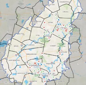
The team described the climate vulnerability assessment now underway, its community-engagement efforts, planned data analysis and implementation pathways, and a new GIS online hazard analysis mapping app that will be maintained and can be crowdsourced.
In her introduction, Rita Gibes Grossman, president of the Boxborough Conservation Land Trust, noted that while Boxborough borders no rivers, its tributary brooks and streams are 55% in the SuAsCo watershed and 45% in the Merrimack, and the town needed to engage with both in planning. Wayland is 96.4% in the SuAsCo watershed and 3.6% in the Charles River watershed, at its southeast corner.
The team has identified technical needs for GIS-based hazard analysis, critical-infrastructure asset inventory and prioritization. The team also includes specialists who contribute social resilience, equity, and resilience-financing expertise. Community input, however, will inform the analysis and regional priorities.
FEMA flood maps have not been updated for future climate conditions and the Collaborative seeks input from locals providing “ground truth” knowledge on what currently happens in their neighborhoods. Consultant BSC’s 2D flood model will map expected extent and depth for a 100-year rainfall event to 2070, supplementing historical FEMA maps. It is planning-level and may not include every culvert.
Katie Kemen, BSC emergency management expert, introduced the online GIS SuAsCo Climate Vulnerability Assessment Map with directions on how to enter a resident’s location of concern by “dropping a point” on the map and viewing other participants’ comments. Data compiled in the crowdsource will be taken for use for the Climate Vulnerability Assessment on Nov. 21. Location points can continue to be added after the deadline.
Project information and the crowd sourcing map are available on the Organization for Assabet, Concord and Sudbury Rivers (OARS) website. The Concord-based nonprofit OARS has been advocating for clean and healthy rivers and the SuAsCo watershed for all people and wildlife since 1986, adding the Sudbury and Concord Rivers to the original focus of the Assabet River in 2011. OARS is the watershed organization anchoring the collaborative, noted Heather Conkerton, OARS ecological restoration manager.
Participants were asked to consider how hazards affect vulnerable residents. Dr. Neenah Estrella-Luna of Starluna introduced the concepts of consequence and criticality as a measure of what happens to vulnerable people when a climate hazard disrupts or damages an important community asset.
Consequence considers impacts such as new costs, greater risk of losing housing, or reduced access to food and open space. Criticality considers how important the affected asset is and which people may be disproportionately affected if it fails.
Estrella-Luna discussed vulnerability as combining opportunity for exposure, sensitivity, and adaptive capacity. She also emphasized community-specific impacts on people’s health, safety, well-being, and dignity and encouraged participants to identify groups in their communities who may be especially affected.
Small groups were assigned to discuss drought, floods, heat, and severe storms, with participants rotating to a second hazard. Participants generated an expansive list of assets from wastewater and septic issues to beaver dams that protect ecosystems during drought.
They considered how renters would not have access to generators as some private homeowners do during power outages, the expense and difficulty of finding short-term housing in an already strained housing capacity, how to alert those who don’t speak English and many other issues affecting immediate and long-term recovery from an event.
Since neighbors may be the most immediate form of help before public safety, the team was interested in whose informal networks provided assistance to the vulnerable. For example, longtime Pelham Island Road residents have educated newer neighbors on how to prepare for flood events and how to get around afterwards, be it via kayak, DPW truck, or duck boat.
Wayland has multiple bridges that are subject to flooding at Stonebridge Road, Pelham Island Road, Route 20/Boston Post Road, Route 27/Old Sudbury Road, and Sherman’s Bridge Road — all of which at one or more times have been closed due to flooding for weeks or more, as has the intersection of Routes 126, 27 and 20. The closure of Sherman’s Bridge for repairs could show Wayland and Sudbury officials how a prolonged crossing closure affects travel even in non-flood conditions.
Kemen reported that the hazard list will be revisited; wildfire and water quality concerns are represented in supporting spreadsheet details, though they were not among the focus hazards for the meeting.