The second Public Involvement Plan meeting on July 30 involving 195 Main St., the former Department of Public Works garage site, was held per the Massachusetts Contingency Plan regulations governing contaminated site investigations.
Ben Gould from CMG Environmental, the town’s licensed site professional, presented updated investigation findings, solicited public comment on a draft revised Phase 2 scope of work, and opened a formal 30-day comment period that closes Aug. 30.
CMG will file a one-year delay notice with the Massachusetts Department of Environmental Protection (MassDEP) before the Phase 2 deadline. As the horizontal extent of PFAS contamination in groundwater has not yet been established, a Phase 2 report cannot be completed without that information. He framed this as a procedural step allowed under the Massachusetts Contingency Plan — when site-specific circumstances prevent timely compliance — provided the responsible party explains the delay and describes acceleration efforts.
The site (RTN 3-37750 under the MassDEP’s release tracking number system) was Tier 1 classified on Nov. 1, 2023, which started a five-year clock under the Massachusetts Contingency Plan. Under that schedule, the Phase 2 comprehensive site assessment is due first, followed roughly a year later by a Phase 3 remedial action plan, and a Phase 4 remedy implementation plan. A permanent or temporary solution is required by Nov. 1, 2028.
What was originally conceived as a single-parcel investigation at 195 Main St. has expanded substantially due to data from the monitoring wells. Gould noted that a site definition under the MCP covers not just where a release occurred but anywhere contamination attributed to the tracking number has been located above applicable reportable standards for drinking water, groundwater or soil contamination.
Of 21 groundwater samples collected from the site area for PFAS testing, 19 showed PFAS-6 concentrations above the drinking water standard of 20 nanogram per liter (ng/L, or parts per trillion). As the parcels lie within the Zone II Aquifer Protection District for the Happy Hollow wellfields, the groundwater standard equals the drinking water standard. Zone II is generally the area of an aquifer that contributes groundwater to a public water supply well under pumping conditions.
The highest single PFAS-6 result was 532 ng/L. Monitoring well 21, near the center of the former DPW parcel, averaged 408 ng/L across two sampling events. The outermost well on the far east side of the site, MW35, showed 23.4 ng/L, which is still above the standard reading.
Trio of data gaps
Three primary data gaps drive the revised Phase 2 scope of work. First, the horizontal extent of PFAS contamination in groundwater is unknown in all four directions. To find where the plume is below the 20 ng/L PFAS-6 standard, Gould plans a new round of monitoring wells on town-owned public rights-of-way — specifically at the Leahy Street dead end, the Keith Road turnaround, the east dead end of Willow Lane, and on the town-owned wetland parcel at 200 Main St. adjacent to Dudley Pond. Two additional wells are planned on the 201 Main St. middle school property. The consultant said he is deliberately avoiding private property and state highway right-of-way to minimize access and permitting complications.
Second, the vertical component of groundwater flow is unknown. Gould plans to put in a deep couplet well (a pair of monitoring wells installed side by side, with one well screened at a shallow depth and the other at a deep depth). The shallow well (MW-11) will be screened from approximately seven to 17 feet depth while the deep well (MW-11D) will be 35 feet total with a five-foot screen from 30 to 35 feet, providing enough vertical separation to measure upward or downward groundwater gradient.
Sufficient downward groundwater flow could push PFAS contamination into bedrock, where it can travel faster and farther than in overburden soils (glacial till materials above the bedrock).
Third, hydraulic conductivity — how fast water moves through the subsurface soils — has not been measured. Combined with the groundwater flow gradient, Gould will have a better conceptual model for calculations of how fast the contamination plume is moving.
Once new monitoring wells on the edges are installed, additional planned work includes a simultaneous PFAS sampling round from all available wells to produce a single-point-in-time snapshot of plume conditions; retesting of well MW5 for soluble antimony (detected once, not detected on resampling); possible sampling of the middle school septic tank effluent directly; and possible surface water sampling at the Dudley Pond wetland area at 200 Main St.
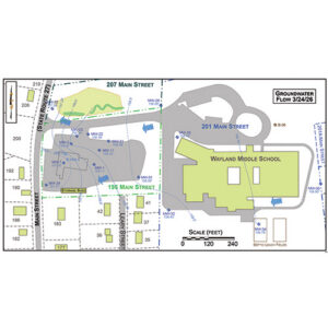
Groundwater flow direction was monitored approximately every two months from May 2025 through March 2026, including a February 2026 round delayed by snowstorms. The dominant flow is westward toward Dudley Pond, but the pattern is complicated by a buried bedrock ridge that divides the parcel roughly north to south down through the center of the middle school building. That ridge was discovered when drilling crews tried five times in a 30- to 40-foot area and hit bedrock each time without reaching the water table.
When the water table is high, groundwater flows uniformly west. When the table drops, the ridge deflects some flow eastward, toward what Gould estimated might eventually reach Lake Cochituate.
For the volatile petroleum hydrocarbon contamination, mostly gasoline, in the soil at 195 Main St., Gould’s model has the most likely source being a leak from underground storage tank piping. The former DPW facility had multiple tanks for gasoline, diesel, fuel oil, and waste oil, plus underground piping for a vehicle-washing recycling system. The contamination’s vertical position — below the water table, at 14 to 17 feet — is consistent with a historical release from leaky piping, though the horizontal location does not align precisely with known tank positions, leaving some uncertainty.
For elevated metals in soil, Gould pointed to the former town landfill that operated at the site from roughly the 1920s to 1958 and extended north across the Middle School entrance road onto 207 Main St. and possibly to the edge of 201 Main St. The mostly vacant 207 Main St. lot includes wetlands and a bioswale installed around 2006 in connection during roadway improvements for the middle school entrance. Previous consultants had mapped the landfill footprint based on historic testing, and his maps largely overlap with those prior assessments.
For PFAS, the working hypothesis is that floor-cleaning compounds used at the Middle school in past decades entered the septic system and leach fields, from which the resulting plume migrated westward to the DPW parcel.
Gould lacks documentary proof of which specific products were used, but said he inferred it from findings at the high school, where previous consultants identified PFAS associated with similar cleaning compounds, reasoning that the town likely purchased products for all schools simultaneously.
Attendee Tom Siacca, who said he participated in those earlier high school investigations, disputed the certainty of that inference:
“I was involved in those earlier investigations at the high school and I don’t remember any confirmation that they were actually the cleaning compounds,” Siacca said. “I think that’s an open issue.”
Siacca also emphasized the importance of resolving vertical groundwater flow direction near Dudley Pond to determine whether PFAS is reaching the pond surface or the groundwater beneath it heading toward the wellfields.
Attendee Marsha Berger, president of Clean Properties, raised the possibility that the apparent concentration hotspot in the middle of the former DPW parcel might represent a point source — possibly related to the stormwater drain system or historic dumping — and asked whether expedited spot removal had been considered rather than waiting for full plume delineation.
“To me, it’s almost like an emergency to see that high concentration in the groundwater, if it’s potentially headed to the town wells,” Berger said.
Gould pointed out that the groundwater travel path to the wells runs through Dudley Pond — roughly a mile and a quarter of surface water — before reaching the well intake. He said that he could not responsibly plan remediation before knowing the full extent of the problem.
Berger also pointed out that the stormwater drain running just north of the former DPW building appears to coincide with the highest concentration readings, and suggested it might be acting as a preferential pathway or a drain for the PFAS plume. Gould said this is consistent with his observations: during high water-table periods, flow moves away from the drain; during low periods, the drain appears to act as a sink pulling groundwater toward it.
From the 1800s, the area around 195 and 207 Main St. was used as a sand and gravel quarry. During the 1920s to 1958 the parcels were used as municipal dump/landfill which included burn pits. In 1943 a DPW building was visible in aerial photographs. In 1969, the town constructed a new DPW building. In 1972, the new junior high was constructed (changed to Wayland Middle School in 1990; renovation added the northeast wing in 1994).
The 195 Main St. site was used by the DPW for fueling operations including underground storage tanks for gasoline, diesel, fuel oil, waste oil for town vehicles and equipment, vehicle/equipment maintenance and washing, and indoor wash bays with floor and trench drains to a recycling system, oil/water separator, leach pit, and a later storm drain connection.
In 1988, 1,400 cubic yards of soil contaminated by #6 heating fuel from a leaking underground storage tank at Claypit Hill School was mixed with asphalt in a DPW garage parking lot extension. In 1996-97, a MassDEP program excavated and removed leaching pits and five underground storage tanks. Multiple MassDEP required investigations ensued to study the site and groundwater contamination. In 2001 the aquifer protection map was amended at Annual Town Meeting.
In 2015, DPW moved to the new 66 River Road building, and the old DPW building was demolished in 2019. An environmental site assessment was performed in March 2022 by CMG as part of a feasibility study for a grass field at the site. The limited subsurface investigation of soil and groundwater triggered a 120-day reporting notice as a site for volatile petroleum hydrocarbons, lead and zinc in the soil, and soluble antimony and PFAS in groundwater.